


Iceland Map Poster from 1901-1928 - 3d rendered version
Modernized version raised relief version, made by using old map textures laid on 3d models derived from modern digital elevation models of the landscape of Iceland.
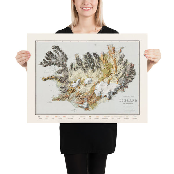
Geological Map of Iceland
Author: Þorvaldur Thoroddsen
Country: Denmark
Publication year: 1901
Scale: 1:600 000
3d render version: Maps of Iceland
In 1882 a young natural scientist, Thorvaldur Thoroddsen (1855-1921), set out to explore the country. He travelled around most of it between 1882 and 1898. His main project was however to investigate the geology of the country with a special focus on volcanic remains. He was the first person who explored and mapped the wasteland west of Vatnajokull, a place that Bjorn Gunnlaugsson never visited and was led astray by stories of uninformed people. Nobody had passed through large parts of this region, this being the country’s last frontier to be explored.
In 1900 Thorvaldur Thoroddsen published a new complete map of the country in two sheets: Uppdráttur Íslands (Kort over Island). In that map he compiles his adjustments and appendixes and adapts them to Gunnlaugsson’s map. A year later his Geological Map of Iceland was published. The map is in fact the same as the map of the year before, with geological colors added.
This raised relief version of the map is designed by Maps of Iceland
Topographic Map of Iceland
Author: Samúel Eggertsson
Country: Denmark
Publication year: 1928
Scale: 1500 000
3d render version: Maps of Iceland
This topographic map of Iceland was published in 1928, illustrated by an Icelandic artist by the name of Samúel Eggertsson. Samúel was a schoolteacher and illustrator that made several well known maps and map themed illustrations, i.e. diagrams of where the settlers of Iceland came from, diagrams of Icelandic mountains and rivers, diagrams of ocean currents around Iceland, as well as illustrating portraits of famous Icelandic poets.
In the years 1909-1919 Samúel spent the majority of his time surveying and mapping various parts of Iceland for private companies, the church, and the government. This beautifully colored topographic map was commissioned by the Association of Icelandic Schoolteachers and published in 1928, primarily meant for use in schools all around the country.
This raised relief version of the map is designed by Maps of Iceland
These maps raised relief version of the map is designed by Maps of Iceland.
About print
Museum-quality posters made on thick and durable matte paper. Add a wonderful accent to your room and office with these posters that are sure to brighten any environment.
• Paper thickness: 10.3 mil
• Paper weight: 5.57 oz/y² (189 g/m²)
• Giclée printing quality
• Opacity: 94%
• ISO brightness: 104%